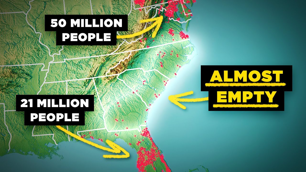
Why The US Southeast Coast is Absurdly Empty
video description
Date: 2025-09-01
Related videos


Comments and reviews: 20
piercemaciain4847
To say Savannah is a naturally deep harbor really isn’t true. One reason that Charleston was so much more important in the Antebellum Era was that you had to be cautious of the tide at Savannah as the Savannah River at the historic port (now River Street tourist area) was only 11 feet deep at mean low tide. Some merchant ships could handle this but there were naval vessels that had to time movement with the tide. Now at mean low tide is over 52 feet deep, thanks to dredging, allowing for the biggest of container ships to service the port including Panamax ships too big to get through the Panama Canal. It’s a lot of dredging too as the River St. area is roughly one mile, the modern port is just upriver (west) but runs about two miles. Then you have River Street to then coast running 17 miles. The reason Savannah was settled so far inland was that it’s built on some of the limited high ground in Chatham County. Yamacraw bluff is high enough to never flood from storm surge being between 40 ft to just under 50 ft above sea level.
An interesting fact because of the Georgia Bite causing the coast of Georgia to be further west than neighboring states and Savannah being built 17 miles inland it is the furthest west port of any port on the Eastern Seaboard.
Great video though and I was really impressed with how accurate some of the odd facts about Georgia were such as pointing out that Atlanta began as Terminus as many think it’s first name was Marthaville which actually was the interim name between Terminus and Atlanta. As well the discussion of the constant issue of Malaria as many would assume Yellow Fever was the constant problem and although there were many catastrophic Yellow Fever outbreaks Malaria was a persistent problem every summer.
reply
Noam-w1l
Anyone who's driven through those southeastern coastal areas can instantly answer the question: they are terribly sulfurous and swampy and hurricane prone. There aren't that many great sites for port cities - what few exist you've already named in the video; maybe you overlooked Brunswick, GA.
You also misstate the problem - Richmond, VA, Washington, D. C, Baltimore, MD and Philadelphia PA are part of the northeastern coastal megapolis but they are also well inland of their actual coastlines - it's like 75 to 150 miles from any of those cities to an actual oceanfront beach. Even Boston is not really on the exposed coastline because Cape Cod curls around to create the large and protected Massachusetts Bay.
Florida is pretty unusual in having big cities pretty much hard up on the coast. That's a function partly of geology (the buildable coral ridges are actually right near the oceanfront areas while inland tends to be swampier, especially from Lake Okeechobee on south in the everglades, and partly because the tropical climate makes for incredibly balmy winters, so after WWII people were willing to expend a lot engineering effort to make the Florida beaches buildable so they could live there - the climate in Savannah or Charleston is not nearly so attractive or worth the effort.
And of course, NYC is pretty close to the open ocean, which was a huge factor in making it the dominant northeastern port city for so long.
reply
stewartgames6697
Charleston has also been all but destroyed twice in history. Between 1863 to 1865, the Union navy bombarded Charleston as a way to punish South Carolina, the first state to secede. Charleston lost around half its antebellum population by the end of the Civil War, and most of the structures built along its harbor and historic Battery Park were severely damaged or demolished by artillery rounds. Only two decades later, Charleston would be struck by one of the strongest earthquakes to ever hit a major city in the United States, the 1886 quake which was estimated between a 6. 9 to 7. 3 on the Richter scale. Almost all 8, 000 of Charleston's downtown buildings were flattened by the quake, as the tremors triggered liquefaction of the underlying soil layers, causing the ground to temporarily function more like a liquid. So twice in just twenty years, the city had to be rebuilt from the ground up, and it was essentially set back decades behind every other major Southeast city demographically.
reply
Colonel_RamRod
Grew up in Rockingham NC and currently in the blue ridge mountains of the same state. I would tell anyone interested in visiting/moving, it gets super effing cold around the end of august. Or that’s the beginning it’s about 55 rn which is fall. By December you’ll have at least a week or two of one/two feet of snow depending. Buy a Subaru if you wanna get around and not have to have a separate vehicle. It’s hot as balls below the line where I grew up. Great four wheeler trails, summers can get to 100 even 105 F. Laugh when I see British people whining about 86F online being hot. Go back and visit a few times a year. NC and specifically its mountains are Gods country and I can’t be convinced otherwise. It’s just too beautiful and there’s so much nature that there just isn’t in other states I’ve been to. It’s like a fortress the way the mountains cut through the roads.
reply
hclnet
Growing up in Columbus Ga, the fall line was always mentioned in history of the city and state. When that was displayed in the graphics my first thought was oh it's that fall line isn't it Of the few things I remember from history/geography class, I think another reason for Atlanta's location is it's around the northernmost navigable part of the Chattahoochee River. You could reach the gulf by taking the train to Atlanta, crossing the fall line at Columbus, and coming out at Apalachicola.
reply
michaell. 5576
I grew up in Pittsburgh. Used to be outside all day, every day, during summer. I was in the woods, riding bikes, and playing pickup games of football, kickball, etc. Hardly ever had a problem with bugs. Then I moved to Atlanta. Damn, the summers are unbearably hot and humid in comparison to Pittsburgh. Plus, the mosquitoes will eat you alive in some spots. I can understand why the kids around here stay indoors mostly during summer.
reply
youdotoo3
Wilmington is the only city in the us to have to have it's government overthrown. Also, Morehead City has a bulk port that is used to recover rocket capsules. Import windmills and export lumber products. The original Capital of NC was New Bern. The coast of nc is primarily used for the military. Also north carolina has one of the worlds largest military terminals Sunny point that is also located on the cape fear
reply
t. b. flowers8903
Wealthy residents in SE US coastal/river cities often had second homes in the same 'city', but further inland, on higher ground or 'bluffs' where they'd retreat to during summer.
You can still see some of the petrified wooden flood gates in the old rice paddies along the coast lines of the southeast.
Atlanta's Terminus was created between the established cities of Decatur 1822 and Marietta 1830s.
reply
eurodoc6343
Some of these same factors continue up the Atlantic coast up into New Jersey. New Jersey has the same unstable barrier islands as NC, but less severe weather. The land behind the barrier islands are mostly swamp and pine barrels, and the rivers that open up at the coast don't really lead anywhere useful. The barrier islands are developed, but there's no real major cities.
reply
reallifelore
So. this story showed up in my feed for two days. I finally decided to watch it. I had no idea about the wealth of information I was about to get! WOW! I don't know where RLL has been hiding all this time, but man am I glad we found each other! I sub'd about 1/2 way through this video-- VERY IMPRESSIVE! I WILL be looking for more from you guys from here on!
reply
BenjaminGunnell
The pronunciations are disturbing, especially of Cape Hatteras. The last syllable is de-emphasized like in most English pronunciations. The default accent in the USA is Ohio for the media. The video is great and the narrator does a good job, but that location is irritating. It sounds like a Canadian is pronouncing locations as they are written. Aye
reply
sambroderick5156
Malaria insects are the only thing in this video to differentiate between NC SC GA and Florida. Florida had at least as much swamps, although much has been drained, and more hurricanes. One used to regularly see cars with headlight bras to prevent mosquitoe damage in Florida, but mosquito populations are down drastically these days.
reply
XxTwentySevenxX
Those wetlands used to be pretty strictly protected, bc they are an integral part of our natural water system. So you couldn't develop on or too near them. They reduced or in some cases just did away with those protections in many locations. So now they can build what ever they want now, so don't worry they won't be sparse for long
reply
atlantakid18
I’m from the Athens area of Georgia, in the Piedmont region, the GA coast is just shitty land with terrible beaches and awful weather. There’s a reason Georgians vacation to Florida, even though we have our own beaches closer byeverything east of the fall line just sucks.
That’s the entirety of your video right there lol
reply
Rexluna1
9: 00 that’s incorrect. The coastal plain soils are more useful than the piedmont soils for agriculture. The less green color is in fact because of that higher fertility and productivity because more of the land is being farmed in satellite photos while west of the fall line you have more pasture and less intensive farming
reply
slickjim861
Short answer, it’s all farmland, chicken houses, hog farms every so many years a hurricane comes through and either flattens, floods, or spawns tornadoes that destroy lots of stuff since the land is pretty dang flat, flooding is truly the worst part for this reason insurance is crazy high from what I understand.
reply
chlorineii
The Savannah/Hilton Head area has been going through extreme population growth the last couple of years, but it can be difficult to expand because of the marshes. They’ve had construction nonstop everywhere for years, but in places like Beaufort, it’s incredibly difficult to expand near marshland.
reply
frankfilippelli
And of course you can’t talk about the Fall Line without mentioning the importance of the largest waterfall on the east coast, the Great Falls of Paterson, NJ which are at the top of the fall line and started this trend as the first planned industrial city founded by Alexander Hamilton.
reply
And of course you can’t talk about the Fall Line without mentioning the importance of the largest waterfall on the east coast, the Great Falls of Paterson, NJ which are at the top of the fall line and started this trend as the first planned industrial city founded by Alexander Hamilton.
reply
jameshunt5504
You can live about 2 hours from coast line in Charleston where you visit for the summers for a quarter of the price. The cost of living on coast line is not made for the middle class or families. People would rather save and have a better daily life than grinding day to day to survive.
reply
You can live about 2 hours from coast line in Charleston where you visit for the summers for a quarter of the price. The cost of living on coast line is not made for the middle class or families. People would rather save and have a better daily life than grinding day to day to survive.
reply
reallifelore
Spray DBT creating Polio and then big pharma’s big push to vaccines saved us all instead of sicker propaganda. There could be a good one or two but we’ve created everything and it’s why countries still using dbt today have polio and their vax does nothing.
reply
Spray DBT creating Polio and then big pharma’s big push to vaccines saved us all instead of sicker propaganda. There could be a good one or two but we’ve created everything and it’s why countries still using dbt today have polio and their vax does nothing.
reply
Add a review, comment
Other channel videos