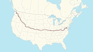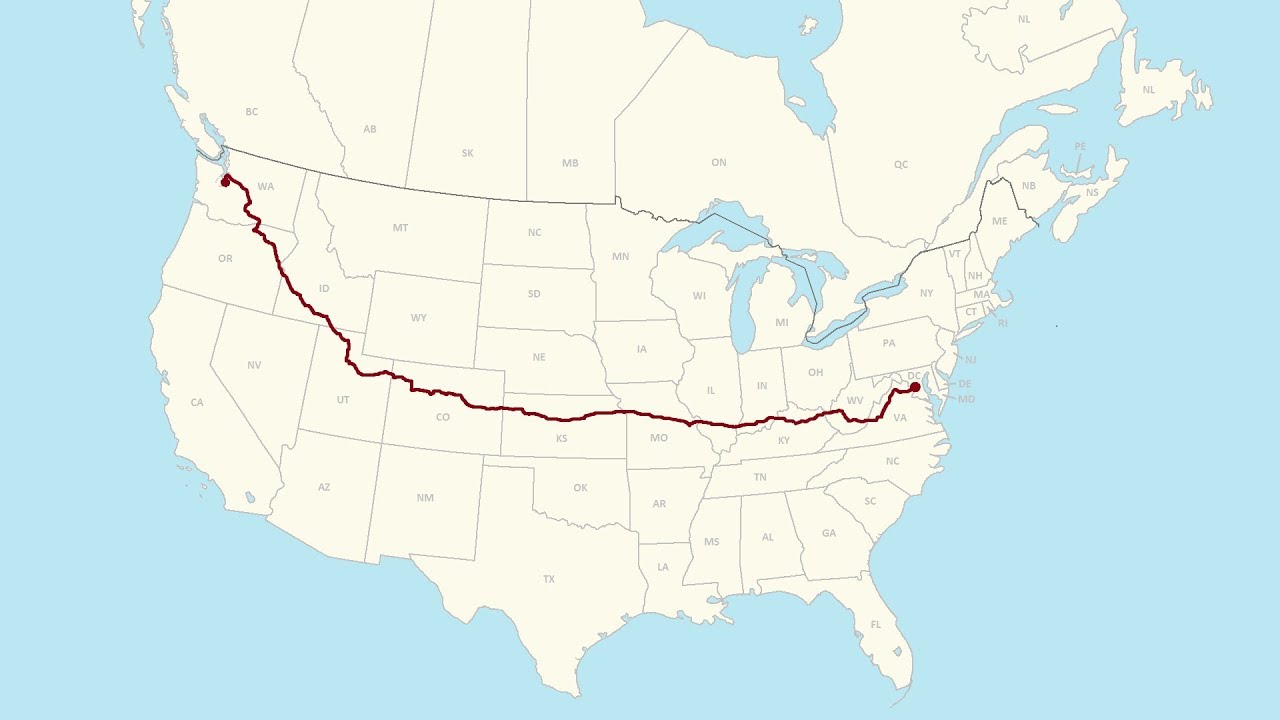
Washington, DC to Seattle, WA: A Complete Road Trip
video description
Date: 2024-01-15
Related videos


Comments and reviews: 33
antonnurwald5700
I love this video. Somehow I prefer an East to West roadtrip to the other direction. The choice of route is excellent! One thing surprised me more than everything else though: The elevation profile! So apparently, in the Appalacian states you are still lower than on the plains. I did not expect that! Also, it's amazing how ever so gently the land slopes upward from Kansas to Colorado. It's flat like a table, still you go up all the time. And then, once you get to Denver, boom! You'r ein the Rockies (or maybe the playback speed makes it look that way. Love it! I definitely want to drive this part one day. Drove around Yellowstone a bit once and also the Cascade Range. Some of those mountain roads gave me the creeps though.
reply
lauracahill5735
I grew up surrounded by the Appalachian mountains so when we went to visit my brother, his wife, and my niece who live in Norton Kansas last year I was amazed at how open and beautiful the plains were. I'm used to having mountains around me, so all that open landscape was a bit intimidating but I can understand why my brother and his family love it out there. Fun fact, we flew to Denver and drove the rest of the way to my brother's house in Norton, so seeing this video going in reverse on I-70 was a pleasant memory for me. Love your videos of the drive across our beautiful country and can't wait to see more!
reply
usa-by-car
I see this traveler not to not miss Kentucky entirely but he missed some great visuals by using mostly Kentucky built four lane divided highway beautiful route that have nobody on them. I always use thr Parkway -- for example. to go from Henderson to Owensboro to get some wonderful--- very close to the road-- load up your own plate where is Kentucky BBQ at "Monlight Barbecue" in Owensboro on the highway. -
reply
dennisgannon
Too bad the freeways are covered on both sides (for smog reasons, those bushes and trees BLOCK the views. So, when you get to open areas, you get to see a great view. Most of the country is EMPTY, as anyone who has flown on planes can see. Ergo, the depopulation crowd is insane. It must have been hard not to stop and enjoy historic places.
reply
PCLoadLetter961
Man I used to love road trips. Longest one I've ever taken was from home in Grand Rapids, MI to Miami, FL for WrestleMania 28. Reached Dalton, GA on day 1 after about 13 hours and the next day, another 13 hours to reach Miami from Dalton. GA and FL take forever to get through on I-75.
reply
Man I used to love road trips. Longest one I've ever taken was from home in Grand Rapids, MI to Miami, FL for WrestleMania 28. Reached Dalton, GA on day 1 after about 13 hours and the next day, another 13 hours to reach Miami from Dalton. GA and FL take forever to get through on I-75.
reply
johnr9528
Unclecoolie Productions, Question if you have a minute. If you were going westbound from Eastern Pennsylvania to Denver, would you prefer I-70 or I-80 Even I-68 in Maryland to I-79 to I-64 is a more scenic (and miles) but less tolls options. Any preference based on all your experiences
reply
Unclecoolie Productions, Question if you have a minute. If you were going westbound from Eastern Pennsylvania to Denver, would you prefer I-70 or I-80 Even I-68 in Maryland to I-79 to I-64 is a more scenic (and miles) but less tolls options. Any preference based on all your experiences
reply
ultrametric9317
This trip made me remember how much I detest Denver and St Louis and Colorado in general. It isn't warm spit compared to Wyoming and Utah. The western slope is nice. The Rockies in Colorado don't even come close to the Rockies in Wyoming! Also the nastiest people in the country.
reply
This trip made me remember how much I detest Denver and St Louis and Colorado in general. It isn't warm spit compared to Wyoming and Utah. The western slope is nice. The Rockies in Colorado don't even come close to the Rockies in Wyoming! Also the nastiest people in the country.
reply
centuryrox
Wow, DC to St Louis on Day 1, then to Denver on Day 2 That's some serious truckin', man!
By the way, with as flat as eastern Colorado is, I'm surprised you can't see the Rocky Mountains from further away. You don't really see them until the suburbs of Denver.
reply
Wow, DC to St Louis on Day 1, then to Denver on Day 2 That's some serious truckin', man!
By the way, with as flat as eastern Colorado is, I'm surprised you can't see the Rocky Mountains from further away. You don't really see them until the suburbs of Denver.
reply
usa-by-car
LVL kentucky down 2 owensBORO, then the sweet little deserted Audubon parkway of four lane over to henderson ky. Get a Kentucky BBQ sandwich and eat that while driving around Evansville IN and north to the Interstate highway that heads on West .
reply
LVL kentucky down 2 owensBORO, then the sweet little deserted Audubon parkway of four lane over to henderson ky. Get a Kentucky BBQ sandwich and eat that while driving around Evansville IN and north to the Interstate highway that heads on West .
reply
jw5312
It would be awesome if he also showed a ticker in the bottom left that shows accumulated driving time! I know you can estimate by just watching through, but it would be cool nonetheless to get an idea of how long the drive time is taking in real-time!
reply
It would be awesome if he also showed a ticker in the bottom left that shows accumulated driving time! I know you can estimate by just watching through, but it would be cool nonetheless to get an idea of how long the drive time is taking in real-time!
reply
FreshTillDeath56
I live next to DC. It's nice, but I'm ready to move on to somewhere more scenic with state parks everywhere. This is such a great way to see new states in America, thanks for the trip!
reply
I live next to DC. It's nice, but I'm ready to move on to somewhere more scenic with state parks everywhere. This is such a great way to see new states in America, thanks for the trip!
reply
usa-by-car
Yeah! I finished the trip. My favorite state on this trip is Washington State. The hills, mountains, and valleys are gorgeous! Thanks for showing us places I can’t travel to see.
reply
Yeah! I finished the trip. My favorite state on this trip is Washington State. The hills, mountains, and valleys are gorgeous! Thanks for showing us places I can’t travel to see.
reply
martinberzins7478
Around 9am in Virginia and there are so few vehicles! Why are major routes virtually empty In the UK these would be one lane each direction not two for so little traffic.
reply
Around 9am in Virginia and there are so few vehicles! Why are major routes virtually empty In the UK these would be one lane each direction not two for so little traffic.
reply
usa-by-car
Nice video, I have my coast to coast road trip completed last month, I have whole recording with 1TB by gopro, can you guide me how to put together like your video, Thanks
reply
Nice video, I have my coast to coast road trip completed last month, I have whole recording with 1TB by gopro, can you guide me how to put together like your video, Thanks
reply
danielwatts7375
The first minute or so reminds me of those old MapQuest printouts of directions for a long trip and the first three pages are just how to get out of your town.
reply
The first minute or so reminds me of those old MapQuest printouts of directions for a long trip and the first three pages are just how to get out of your town.
reply
cowfat8547
man i really wanna drive around this beautiful country. i might just take a couple months to drive around and explore the country after i finish college
reply
man i really wanna drive around this beautiful country. i might just take a couple months to drive around and explore the country after i finish college
reply
robpittstop1797
Question, buddy, what camera are u using with these information on the screen How were u able to add state, route u are on, time, location
reply
Question, buddy, what camera are u using with these information on the screen How were u able to add state, route u are on, time, location
reply
MotoJake
Watching this all the way through. It’s crazy. The time I’m watching this, it’s at the sam black, WV exit which I live 20 minutes from.
reply
Watching this all the way through. It’s crazy. The time I’m watching this, it’s at the sam black, WV exit which I live 20 minutes from.
reply
EverythingStatsYT
I literally watched the entire video at 0. 25x speed (1x speed irl) the entire time. The whole video took nearly 44 hours to watch.
reply
I literally watched the entire video at 0. 25x speed (1x speed irl) the entire time. The whole video took nearly 44 hours to watch.
reply
marcuscarana9240
It would be so nice to live in the US, but there's so much gun violence and gun massacres it's scary so I'll just stay in Europe.
reply
It would be so nice to live in the US, but there's so much gun violence and gun massacres it's scary so I'll just stay in Europe.
reply
MrAsianPie
As someone from Virginia the segments of Interstate 64 to Missouri brings back memories of summer trips to visit family out west
reply
As someone from Virginia the segments of Interstate 64 to Missouri brings back memories of summer trips to visit family out west
reply
hunterw6102
One thing I love about trucking is the new places I get to see I'd still rather stay away from big cities in a rig though lmao
reply
One thing I love about trucking is the new places I get to see I'd still rather stay away from big cities in a rig though lmao
reply
usa-by-car
when you need one more video to put you to sleep, tunein here . i need driving trip in america-- and you can learn a lot-
reply
when you need one more video to put you to sleep, tunein here . i need driving trip in america-- and you can learn a lot-
reply
tibodeclercq2131
How come kansas is so flat yet you go up in eleation significantly when you cross the state from east to west.
reply
How come kansas is so flat yet you go up in eleation significantly when you cross the state from east to west.
reply
richardthomas5362
6: 08: 53 Elevated section of I-70 - RIP.
Much of this is below ground level, including a tunnel now.
reply
6: 08: 53 Elevated section of I-70 - RIP.
Much of this is below ground level, including a tunnel now.
reply
aldocuneo1140
Driving in HW of grand plains was my worst boring experience in my life. More boring than a baseball match.
reply
Driving in HW of grand plains was my worst boring experience in my life. More boring than a baseball match.
reply
greel7901
Thanks for such an excellent video. I would like to know in which vehicle you made the journey. kind regards
reply
Thanks for such an excellent video. I would like to know in which vehicle you made the journey. kind regards
reply
hayden6700
8: 08: 20 there's Lagoon on the right there in Farmington, glad you made it to Utah the mountains look dope
reply
8: 08: 20 there's Lagoon on the right there in Farmington, glad you made it to Utah the mountains look dope
reply
usa-by-car
Oh done all those pickups do not have a TONNEAU cover above or over there bed to make more aerodynamic.
reply
Oh done all those pickups do not have a TONNEAU cover above or over there bed to make more aerodynamic.
reply
322Marcus
Anyone else just pick a random time stamp and put on a good record while watching the surroundings go by
reply
Anyone else just pick a random time stamp and put on a good record while watching the surroundings go by
reply
usa-by-car
Very interesting how the elevation measured was much higher in flat Kansas than in Virginia and W. V!
reply
Very interesting how the elevation measured was much higher in flat Kansas than in Virginia and W. V!
reply
TM-bd7nf
That is awesome how were able to put your exact location on the map in the upper left hand corner!
reply
That is awesome how were able to put your exact location on the map in the upper left hand corner!
reply
Add a review, comment
Other channel videos